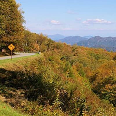
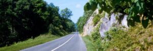
Just a few miles away from our Waynesville bed and breakfast is the Blue Ridge Parkway, one of the most scenic drives in the county. A drive down the Blue Ridge Parkway is slow paced and relaxing with non-stop natural beauty. There are many places to stop along the way. Almost any overlook or hiking trail reveals much of the natural and cultural history here. While many people think of the Blue Ridge Parkway just as a motor road, it is also a place of varied and significant natural resources and part of the National Park Service. The Parkway follows the high crests of the central and southern Appalachians for 469 miles from Shenandoah National Park in Virginia to the Great Smoky Mountains National Park in North Carolina. The Parkway provides wonderful opportunities for:
Wildflowers & Fall Colors – The Parkway provides an excellent location for both wildflower walks in the springtime and brilliant leaf color in the autumn. May is probably the best month for wildflowers. Look for Rhododendron in mid June!
Photography – The combination of historical and natural areas make the park an excellent destination for photographers.
Historical and Cultural Demonstrations – Several developed areas offer hands-on demonstrations of mountain life and culture.
Ranger Guided Walks and Evening Programs – During the summer season, most developed areas offer evening programs, or more traditional campfire programs, along with guided walks and special programs.
Birdwatching – Because the Appalachian Mountains shape the flyway for most eastern migratory birds, the Parkway is an excellent place for both birdwatching and autumn migratory bird counts.
Blue Ridge Parkway, Brookside Mountain Mist Inn
Here is a convenient list of the important spot along the Parkway, arrange by mileage beginning in Asheville and ending at the Great Smoky Mountains National Park:
Milepost 382 The Folk Art Center offers sales and exhibits of traditional and contemporary crafts of the Appalachian Region. Interpretive programs are offered in addition to a gallery and library. Mountains To The Sea Trail and Shut-In Trail.
382.6 U.S. 70, right 5 mi. to Oteen and Asheville; left 9 mi. to Black Mountain. Food and lodging available nearby in either direction.
384.7 U.S. 74, right 5 mi. to Asheville; left 17 mi. to Bat Cave
388.85 U.S. 25, right 5 mi. to Asheville; left 16 mi. to Hendersonville. Nearby; Biltmore House
393.6 N.C. 191 & 280, right 9 mi. to Asheville. Nearby; North Carolina Arboretum. Gardens and Trails. Go North on 191 about 1/4 mile. Follow signs.Blue Ridge Parkway
397.1 Grassy Knob Tunnel, 600ft. long
399.3 Pine Mountain Tunnel,1320 ft. long
400.9 Ferrin Knob Tunnel No.1, Trace Ridge, 360 ft. long
401.3 Ferrin Knob Tunnel No.2, 310 ft. long
401.5 Ferrin Knob Tunnel No.3, 230 ft. long
403.0 Young Pisgah Ridge Tunnel, 400 ft. long
403.9 Fort Mountain Tunnel, 350 ft. long
406.9 Little Pisgah Tunnel, 500 ft. long
407.4 Buck Springs Tunnel, 380 ft. long
407.6 Mount Pisgah parking area. Mt. Pisgah Trail and Buck Springs Trail. Mount Pisgah was part of the Biltmore Estate. The estate became home of the first U.S. forestry school and the nucleus of the Pisgah National Forest. For much more in-depth information on things to see and do in this area of the Pisgah National Forest, also visit our Pisgah Forest section.
408.6 Mount Pisgah Inn restaurant
410.1 Frying Pan Tunnel, 275 ft. long
411.85 Cold Mountain parking overlook, elev. 4542 (See hiking)
411.9 U.S. 276, right 22 mi. to Waynesville; left 17 mi. to Brevard. Nearby: towards Brevard to Cradle of Forestry, Sliding Rock, Looking Glass Rock, Looking Glass Falls and Pisgah Center for Wildlife Education.
417.05 Looking Glass Rock parking overlook (See hiking)
418.8 Graveyard Fields parking overlook (See hiking)
420.2 Balsam Spring Gap, elev. 5550. U.S.F.S. road (gated) right. Access to Black Balsam Knob area of Pisgah NF and Shining Rock Wilderness. (See hiking)
422.1 Devils Courthouse Tunnel, 650 ft. long
422.4 Devil’s Courthouse parking overlook, elev. 5462. Trail. S. Devil’s Courthouse is a rugged exposed mountain top rich in Cherokee legends. A walk to the bare rock summit yields a spectacular view of Pisgah National Forest. (See hiking)
423.2 Beech Gap, elev. 5340. Right 23 mi. to Waynesville; left 17 mi. to Rosman
423.5 Courthouse Valley parking overlook, elev. 5362
423.7 Tanassee Bald
431.0 Haywood-Jackson parking overlook, elev. 6020. Self guiding trail. Richland Balsam’s self-guiding trail takes you through a remnant spruce-fir forest.
431.4 Richland Balsam parking overlook, highest point on Parkway, elev. 6050
439.7 Pinnacle Ridge Tunnel, 750 ft. long
443.1 Balsam Gap, elev. 3370. U.S. 19A & 23, right 8 mi. to Waynesville. **Entrance nearest to Brookside Mountain Mist Inn & Cottages**
451.2 Waterrock Knob parking overlook, Waterrock Knob provides a panorama of the Great Smokies and 4 states. A trail, exhibits, and a comfort station are available. (See hiking)
455.7 Soco Gap, elev. 4340. U.S.19, right 8 mi. to Dellwood; left 12 mi. to Cherokee
458.2 Wolf Laurel Gap, elev.5100. S. Heintooga Ridge spur road goes to a mile-high overlook 1.3 miles from the parkway.
458.8 Lickstone Ridge Tunnel, 402 ft. long
459.3 Bunches Bald Tunnel. 268ft. long
461.2 Big Witch Tunnel, 348 ft. long
465.6 Rattlesnake Mountain No.4 Tunnel, 410 ft. long
466.25 Sherill Cove No.6 Tunnel,572 ft. long
469.1 End of Blue Ridge Parkway. U.S. 441, left 2 mi.to Cherokee, N.C. Southern End of the Blue Ridge Parkway intersects with U.S.
441 in the Great Smoky Mountains National Park and the Cherokee Reservation.After a day of riding on the Blue Ridge Parkway, return to our bed and breakfast inn in Waynesville, North Carolina for a night of luxury accommodations.